THE
LACKAWANNA
TRAIL:
A pictorial presentation of areas of the Lackawanna Trail in Northeastern Pennsylvania (NEPA). Photos, Maps, highlights showing the early transition of the Delaware, Lackawanna and Western Railroad right of way from Scranton to Binghamton, NY.
This page was inspired by several old postcards I discovered. I also recommend a read of the Guestbook on this site. It includes some wonderful insights on the site photos and other areas of interest along "The Lackawanna Trail"
This page
is evolving. Living away from the NEPA area, my only avenue of
research is the Internet and all the people who reply to my guestbook and
various newsgroup posts regarding the Lackawanna Trail. I welcome any
contributions, corrections and suggestions you may provide.
Please Email walt.stevens@comcast.net
The postcards copied herein were published by the Scranton News, there is
no date, the photos on most cards are by Bunnel Photo. 1 I would be very
interested to know if there are any other photos in this series,
I would love to include a copy on the page.
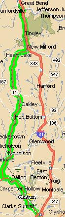
I have included highlighted maps created with Google Maps to show the area of
the Trail. In some instances additional highlights are added to
show where the Trail may have differed from what is now PA Route 11. The
maps are interactive. Experiment with them and experience a virtual
journey through the Abington Mountains and the Lackawanna Trail. Enjoy,
and please contribute, correct or suggest if you can.
Area of the Lackawanna Trail. - from
an Alan C. Jones EMAIL.
"When Delaware, Lackawanna and Western President Truesdale
rebuilt the Lackawanna in the early part of this century, the roadbed was
relocated from the bottom of the valley to the top of the hills between
Scranton and Big Bend. After the reconstruction, most of the old roadbed (after
rail, tie, etc removal) was
GIVEN to the State of Pennsylvania to use as a highway. Today, US Route 11 from
Big Bend to Scranton is either on top of, or very close to, the original
Lackawanna road bed. This road is referred to as "The Lackawanna
Trail". This reconstruction shortened the route by several miles; but, more
importantly, it reduced the maximum grades from nearly 2% down to around
1.1%!"
1.
MAIN
TRAIL LOCATIONS
- Clarks Summit, PA "The
start of the Lackawanna Trail"
- Nicholson, PA "The eighth
wonder of the world"
- Kingsley, PA "The heart of
the Lackawanna Trail"
- Glenburn, PA
"Hairpin turn on the Lackawanna Trail"
- Alford,
PA
"A view of the old and new"
- Foster,
PA
(Hop Bottom) "The beautiful mountains of the Lackawanna Trail"
- Factoryville,
PA "Horseshoe
curve at Factoryville on the Lackawanna Trail"
- New Milford, PA "A Southerly view
on the Lackawanna Trail"
- Montrose
Road
- Great
Bend, PA
"The big cut through scenic mountains"
2.
SCRANTON,
PA VIEWS
- Lackawanna Station,
Scranton PA. DL&W and Lackawanna and Wyoming Valley Laurel Line)
terminals.
- Same view as #1
above, different era
- Laurel Line,
Roaring Brook, Harrison ave bridge - View of Crown ave
tunnel portal.
- Laurel Line
looking east - Tunnel and Over the hill route plus Power House.
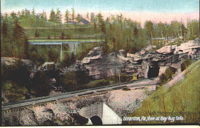
- Nay Aug Tunnel South
Portal - A rare view. Shot taken viewing west across the gorge.
1 Bunnel Photo - Reader Don Dorflinger writes.
"Watson "Wild Bill" Bunnell was one of the two best known company photographers for the DL&W railroad, along with William Barry, Jr. You will find their names on most of the DL&W stuff shot around that era ("Bunnell Photo" or "W.B.B.JR."). It's unclear to me whether Barry worked the east end and Bunnell the west, or what...also, were they actually employed full-time by the Lackawanna, or just contract players? Somehow I have the impression that Bunnell was Barry's protoge' and took over after he retired, but I'm not certain. Some DL&W historian would know. At any rate, copyrights on their stuff has long run out, and the majority of the surviving glass plate negatives are in the collection at Syracuse University."
Email: walt.stevens@comcast.net
LINKS
My Guestbook